Mapoteca / Mapas Extranjeros
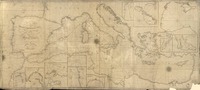
A new and improved chart of the Mediterranean Sea including the coast of Spain and Portugal [material cartográfico] : the lastest authorities by Robert Blachford.

Metadatos
- Título
- A new and improved chart of the Mediterranean Sea including the coast of Spain and Portugal [material cartográfico] : the lastest authorities by Robert Blachford.
- Tipo de acceso
- Acceso en línea
- Tipo
- Material cartográfico
- Datos de Publicación
- London : Robert Blachford, November 11th 1808.
- Descripción Física
-
1 mapa : blanco y negro ; 79 x 178 cm.
- Notas
-
General
Inserto de: Port of Genoa -- Harbour of Toulon -- Leghorn Road -- Alicant Bay -- Straits of Messina -- Malta and Gozzo -- Passage of Dardanells -- Gulf of Smyrna.
"Engraved by S. Stockley" --Mapa.
Forma física adicional disponible
Disponible en formato digital.
Reproducción
Reproducción electrónica. Santiago, Chile : Biblioteca Nacional de Chile, Laboratorio Digital, 2017. Objeto digital: MP0006482
Términos de uso y reproducción
Acceso en línea (dominio público) sin restricción de reproducción.
- Referencia Bibliográfica
-
A new and improved chart of the Mediterranean Sea including the coast of Spain and Portugal / [material cartográfico] : the lastest authorities by Robert Blachford. London : Robert Blachford, November 11th 1808. 1 mapa : blanco y negro ; 79 x 178 cm. .
- Materia
- Cartas náuticas
- Años
- 1808
- Idioma
- eng
- Colección
- Mapoteca / Mapas Extranjeros
- BND Id
- 354294
- Códigos BN
- MP0006482
- Nº sistema
- 1124494
- Miniatura